B
Bob
Guest
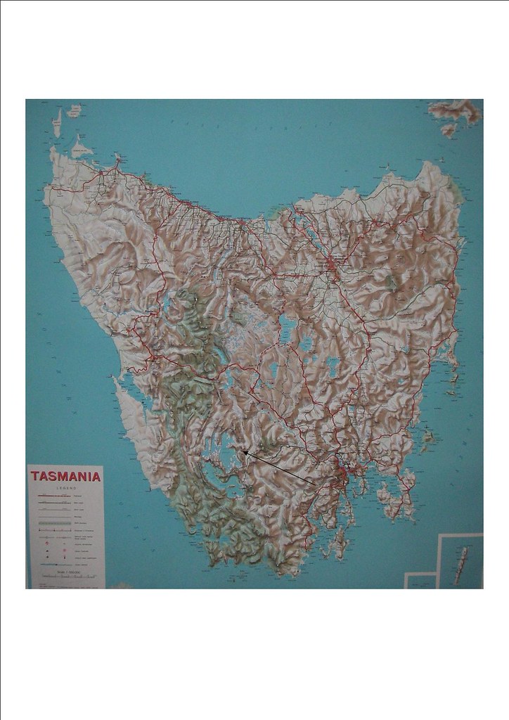
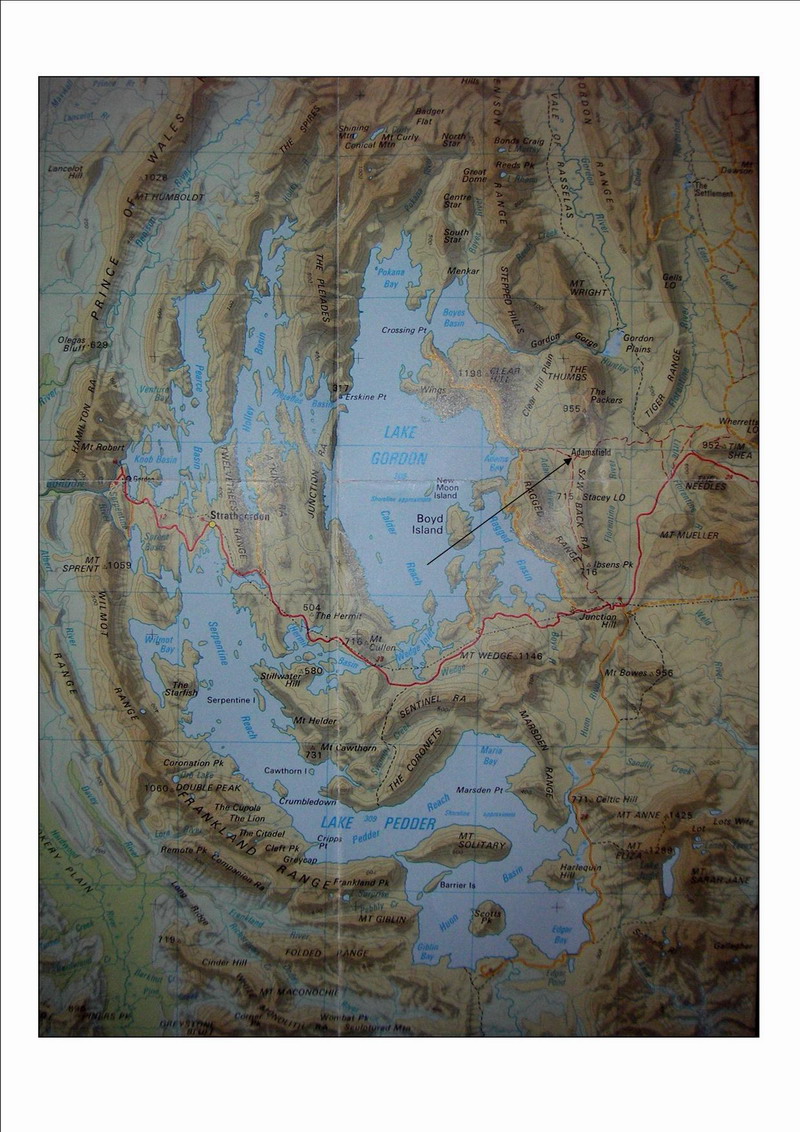
I had heard stories through the media about an old abandoned mining town called Adamsfield. It had captured my interest due to its history and remoteness so I decided to visit the area by motorcycle, if possible. Some research revealed that it could be reached via Forestry roads, so the ride was on.
Adamsfield is located about four kilometres east of the Hydro created Lake Gordon but Lake Gordon didn’t exist when a rich vein of osmiridium was discovered at Adams River in 1925. Access to the area was on foot or with pack-horses along a track taking two days to get from Mt Field.
Osmiridium is a naturally occurring alloy but is extremely rare. It was used to manufacture fountain pen nibs, jewellery, surgical instruments and poisonous gas. In 1925 osmiridium was worth about seven times the value of gold. Adamsfield grew to a town of around a thousand people and the osmiridium was a significant boost to the Tasmanian economy. By the end of world war two few people lived at Adamsfield but mining did continue until the 1960s. All but two huts have been destroyed by fire and the area has been reclaimed by the bush. Mullock heaps and water races are still obvious and the area is one of a number in Tasmania where if you go walking around in the bush you risk falling down a mine shaft.
<?xml:namespace prefix = o ns = "urn:schemas-microsoft-com fficeffice" /><o></o>
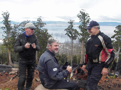
On Saturday 21 Feb. ’09 four of us met at Granton. Between us we were riding a KLR 650, two V Strom 650’s and an Aprilia Pegaso 650. We rode to Mt Field National Park, where we collected the necessary permit and keys for the two gates. Adamsfield is not in a National Park and therefore it is not necessary to purchase a park pass. There is no charge for the permit but there is a $100 deposit on the keys (they swipe your credit card and destroy the slip when you return the key).
<o></o>
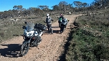
We then rode through Maydena along the Gordon River Road (built in the mid ‘60s for the Lake Pedder/Lake Gordon hydro power scheme). We passed the Greenies who have been based in the Florentine Valley for the past couple of years to protest the logging of old growth forests there. On the eastern side of Lake Gordon we turned off the highway onto Clear Hill Road. It is an unsealed Forestry road and is in good condition. It is easily negotiated by dual sports bikes. Access is through a locked gate.
<o></o>
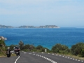
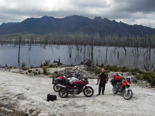
We rode for approximately 20 k’s until we came to a large clearing overlooking Lake Gordon. Here we could eat our lunch while admiring the rugged beauty of the landscape as well as the devastation caused by logging and the flooding of Lake Gordon.
We then explored the Forestry tracks further north to the beginning of the Gordon River, where we stopped at a small lake at the end of the Gordon Gorge. Past the lake was the Tiger Range, presumably named when the now extinct Thylacine roamed the area.
We then road back to the Adamsfield Track, which it seems is alternatively called Morley Track. We were looking for a track with a gate and marked ‘Adamsfield Track’ as shown on various maps. We rode past the turn off before we noticed the obscure sign ‘Morley Track’. The gate was not visible from Clear Hill Rd. Some genius had cunningly located it towards the bottom of a short steep hill and around a bend. Obviously at least one vehicle was unable to stop in time for it and had put a bit of a bend in it. This had resulted in the padlock becoming jammed in its ‘bolt cutter protective tube’. It took us at least twenty minutes to open the gate and we were unable to lock it behind us.
<o></o>
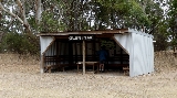
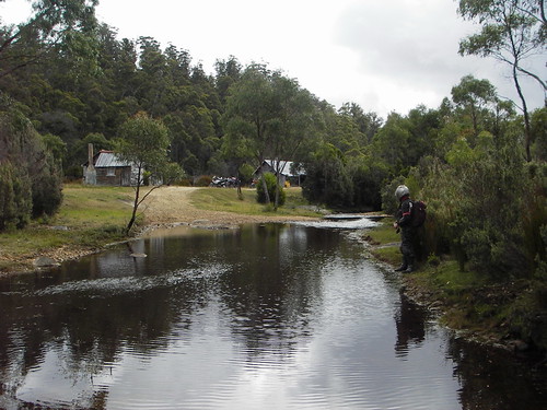
About one kilometre down the track are Clark’s Huts. Built by a miner in 1940’s on the banks of Adams River. They are the only buildings in the area that are still standing. They are in use today and are not open to the public.
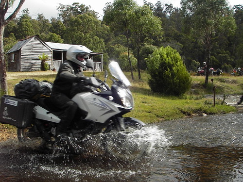
We then had to cross the Adams River. There are two choices with the most direct being the easiest for a motor bike.
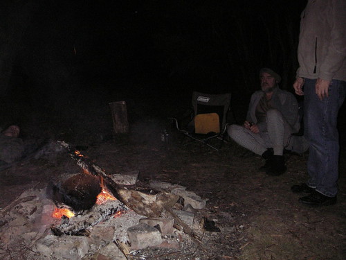
About 500 metres on is a large clear area where buildings once were. The only building there now is a tin lean-to over a pit toilet. The area is close to the creek and provides good camping. Fortunately someone before us had left a few logs and we were able to have a good sized fire to relax by that night.
Next morning we rode a short distance toward the site of the Adamsfield township and walked the final kilometre as we were unsure of the state of the track. As it turned out we could have ridden all the way but we have been informed that the Saw Back track that joins with the Adamsfield track a short distance east of Adamsfield is serious 4wd. and trail bike territory.
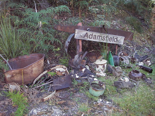
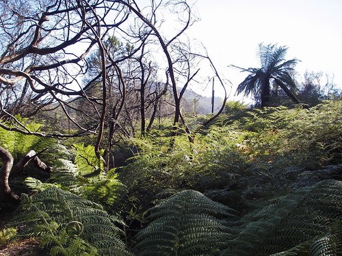
The township site has completely overgrown with scrub although it is still possible to work out where streets must have been. A solitary telegraph pole stands amongst the bracken and man-ferns. The extensive system of water races which once fed the hydraulic mining are still visible.
We then headed for home. We decided against filling our water bottles at the river crossing as we would soon be at Mt Field or so we thought.
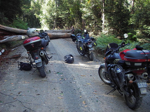
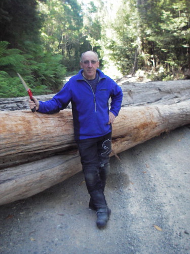
About a kilometre from the Gordon River Road / Clear Hill Road junction our path was blocked by a very large tree that had fallen across the road. There hadn’t been high winds to push it over. It was just one of the old large trees with the top broken out of it that the Forestry operators leave to provide habitat for wild life as the forest re-establishes after the logging and regeneration burn. These trees usually are partially rotten as was the one that had so inconveniently fallen across our path. We considered our options and decided that there was no way under, around or over it.:bang:
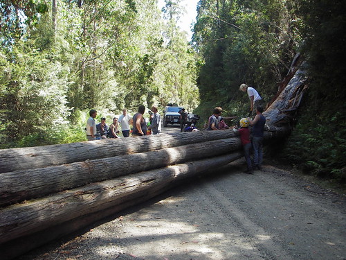
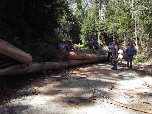
One of us walked out to the main road and asked some tourists to contact Mt Field Nat. Parks officers to let them know that we were stuck there. A short time after his return another group of people and vehicles arrived behind us. They had been camping in another area but also had to get out to the main road. They had a chainsaw but initially didn’t think that it was big enough to cut through the tree. However one of them, who worked in the forestry industry, decided to have a go at it. After a quite a technical operation using the chainsaw, car jacks and a winch a path was cleared through the tree. It took two hours and was somewhat of an accomplishment considering the equipment available.
<o> </o>
</o>
[/font]
Adamsfield is located about four kilometres east of the Hydro created Lake Gordon but Lake Gordon didn’t exist when a rich vein of osmiridium was discovered at Adams River in 1925. Access to the area was on foot or with pack-horses along a track taking two days to get from Mt Field.
Osmiridium is a naturally occurring alloy but is extremely rare. It was used to manufacture fountain pen nibs, jewellery, surgical instruments and poisonous gas. In 1925 osmiridium was worth about seven times the value of gold. Adamsfield grew to a town of around a thousand people and the osmiridium was a significant boost to the Tasmanian economy. By the end of world war two few people lived at Adamsfield but mining did continue until the 1960s. All but two huts have been destroyed by fire and the area has been reclaimed by the bush. Mullock heaps and water races are still obvious and the area is one of a number in Tasmania where if you go walking around in the bush you risk falling down a mine shaft.
<?xml:namespace prefix = o ns = "urn:schemas-microsoft-com
fficeffice" /><o></o>On Saturday 21 Feb. ’09 four of us met at Granton. Between us we were riding a KLR 650, two V Strom 650’s and an Aprilia Pegaso 650. We rode to Mt Field National Park, where we collected the necessary permit and keys for the two gates. Adamsfield is not in a National Park and therefore it is not necessary to purchase a park pass. There is no charge for the permit but there is a $100 deposit on the keys (they swipe your credit card and destroy the slip when you return the key).
<o
></o>We then rode through Maydena along the Gordon River Road (built in the mid ‘60s for the Lake Pedder/Lake Gordon hydro power scheme). We passed the Greenies who have been based in the Florentine Valley for the past couple of years to protest the logging of old growth forests there. On the eastern side of Lake Gordon we turned off the highway onto Clear Hill Road. It is an unsealed Forestry road and is in good condition. It is easily negotiated by dual sports bikes. Access is through a locked gate.
<o
></o>We rode for approximately 20 k’s until we came to a large clearing overlooking Lake Gordon. Here we could eat our lunch while admiring the rugged beauty of the landscape as well as the devastation caused by logging and the flooding of Lake Gordon.
We then explored the Forestry tracks further north to the beginning of the Gordon River, where we stopped at a small lake at the end of the Gordon Gorge. Past the lake was the Tiger Range, presumably named when the now extinct Thylacine roamed the area.
We then road back to the Adamsfield Track, which it seems is alternatively called Morley Track. We were looking for a track with a gate and marked ‘Adamsfield Track’ as shown on various maps. We rode past the turn off before we noticed the obscure sign ‘Morley Track’. The gate was not visible from Clear Hill Rd. Some genius had cunningly located it towards the bottom of a short steep hill and around a bend. Obviously at least one vehicle was unable to stop in time for it and had put a bit of a bend in it. This had resulted in the padlock becoming jammed in its ‘bolt cutter protective tube’. It took us at least twenty minutes to open the gate and we were unable to lock it behind us.
<o
></o>About one kilometre down the track are Clark’s Huts. Built by a miner in 1940’s on the banks of Adams River. They are the only buildings in the area that are still standing. They are in use today and are not open to the public.
We then had to cross the Adams River. There are two choices with the most direct being the easiest for a motor bike.
About 500 metres on is a large clear area where buildings once were. The only building there now is a tin lean-to over a pit toilet. The area is close to the creek and provides good camping. Fortunately someone before us had left a few logs and we were able to have a good sized fire to relax by that night.
Next morning we rode a short distance toward the site of the Adamsfield township and walked the final kilometre as we were unsure of the state of the track. As it turned out we could have ridden all the way but we have been informed that the Saw Back track that joins with the Adamsfield track a short distance east of Adamsfield is serious 4wd. and trail bike territory.
The township site has completely overgrown with scrub although it is still possible to work out where streets must have been. A solitary telegraph pole stands amongst the bracken and man-ferns. The extensive system of water races which once fed the hydraulic mining are still visible.
We then headed for home. We decided against filling our water bottles at the river crossing as we would soon be at Mt Field or so we thought.
About a kilometre from the Gordon River Road / Clear Hill Road junction our path was blocked by a very large tree that had fallen across the road. There hadn’t been high winds to push it over. It was just one of the old large trees with the top broken out of it that the Forestry operators leave to provide habitat for wild life as the forest re-establishes after the logging and regeneration burn. These trees usually are partially rotten as was the one that had so inconveniently fallen across our path. We considered our options and decided that there was no way under, around or over it.:bang:
One of us walked out to the main road and asked some tourists to contact Mt Field Nat. Parks officers to let them know that we were stuck there. A short time after his return another group of people and vehicles arrived behind us. They had been camping in another area but also had to get out to the main road. They had a chainsaw but initially didn’t think that it was big enough to cut through the tree. However one of them, who worked in the forestry industry, decided to have a go at it. After a quite a technical operation using the chainsaw, car jacks and a winch a path was cleared through the tree. It took two hours and was somewhat of an accomplishment considering the equipment available.
<o
>>[/font]
Last edited:


