
penguineer
just luscious
Went for a quick ride this afternoon - playing with my phone and just wanted to clear my head a bit, nothing serious, just a loop of Mount Tamborine.
I've been having problems with my mobile phone and it's data connection dropping out at various times. To try to determine if it's the phone or the tower it is connected to I figured I would visit a few locations near good coverage(funnily enough, most of the lookouts have mobile phone towers right next to them) and at the same time give a new version of Joel Tolberts' most excellent BubblerGPS software a minor workout.
For those that don't know - BubblerGPS is an Android phone app that ties into Spotwalla.com to allow you to create maps of your trips suitable for the folks at home to follow and allows you to send simple updates such as photos. On this short ride I was mainly just exercising the software through tracking updates and submitting photos. Most of the photos below are from the mobile camera, so marginal quality.
First stop was the Hangliders lookout - at this point my phone managed to reboot itself several times, but eventually came good. Looked to be a bit of a fire off to the southwest and it's still early enough that the sunset watchers aren't out in force.....

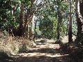
Next I went down Beacon road, past the distillery and wineries to the lookout next to the "dry" conference centre and church camp(temptation before the Lord perhaps?).
Lots of trees in the pic - it's actually better than this:

Now to the Knoll National Park lookout, but first check on a small friend who isn't home, but I photograph his place anyway:

This is the bower of a Satin Bower bird - elegantly constructed, with room for dancing and tastefully decorated with whatever takes the fancy......the ladies really dig blue apparently.....
The lookout:

Again - the photo doesn't do it justice, but I reckon that big tree in the middle is going to undergo an "accident" one of these days....
No time for photos on the road off the mountain - 54 curves in less than seven kilometers(a shade under four and a half miles). Unfortunately I get behind a car at the top of the hill, so I slow down to give them a headstart before getting into the groove(still managed to catch up before the bottom of the hill).
A quick short-cut to the start of Mundoolin Connection as the sun starts to drop and the sky changes colour:

The Outpost is generally busier, bu a lot of Canungra shuts after five(including the servo):

I headed home via the Goat Track - intending my final photo to be the traffic lights controlling the narrow one-way section, but decided to double back....
This is the Goat Track:

And this is a Unicycle:


Turns out he is a local and he's on his return trip down the hill. If that's not enough, he did the run up to O'Reillys yesterday......madness....
Eventually ended up heading up Henri-Robert drive just as it got properly dark....
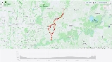
Todays trip: https://spotwalla.com/tripViewer.php?id=895f52d5271b0add2
And, if all appropriate deities are in alignment, an embedded map: (apparently not)
Cheers!
I've been having problems with my mobile phone and it's data connection dropping out at various times. To try to determine if it's the phone or the tower it is connected to I figured I would visit a few locations near good coverage(funnily enough, most of the lookouts have mobile phone towers right next to them) and at the same time give a new version of Joel Tolberts' most excellent BubblerGPS software a minor workout.
For those that don't know - BubblerGPS is an Android phone app that ties into Spotwalla.com to allow you to create maps of your trips suitable for the folks at home to follow and allows you to send simple updates such as photos. On this short ride I was mainly just exercising the software through tracking updates and submitting photos. Most of the photos below are from the mobile camera, so marginal quality.
First stop was the Hangliders lookout - at this point my phone managed to reboot itself several times, but eventually came good. Looked to be a bit of a fire off to the southwest and it's still early enough that the sunset watchers aren't out in force.....
Next I went down Beacon road, past the distillery and wineries to the lookout next to the "dry" conference centre and church camp(temptation before the Lord perhaps?).
Lots of trees in the pic - it's actually better than this:
Now to the Knoll National Park lookout, but first check on a small friend who isn't home, but I photograph his place anyway:
This is the bower of a Satin Bower bird - elegantly constructed, with room for dancing and tastefully decorated with whatever takes the fancy......the ladies really dig blue apparently.....
The lookout:
Again - the photo doesn't do it justice, but I reckon that big tree in the middle is going to undergo an "accident" one of these days....
No time for photos on the road off the mountain - 54 curves in less than seven kilometers(a shade under four and a half miles). Unfortunately I get behind a car at the top of the hill, so I slow down to give them a headstart before getting into the groove(still managed to catch up before the bottom of the hill).
A quick short-cut to the start of Mundoolin Connection as the sun starts to drop and the sky changes colour:
The Outpost is generally busier, bu a lot of Canungra shuts after five(including the servo):
I headed home via the Goat Track - intending my final photo to be the traffic lights controlling the narrow one-way section, but decided to double back....
This is the Goat Track:
And this is a Unicycle:
Turns out he is a local and he's on his return trip down the hill. If that's not enough, he did the run up to O'Reillys yesterday......madness....
Eventually ended up heading up Henri-Robert drive just as it got properly dark....
Todays trip: https://spotwalla.com/tripViewer.php?id=895f52d5271b0add2
And, if all appropriate deities are in alignment, an embedded map: (apparently not)
Cheers!
