penguineer
just luscious
Day 5 - Views, scents and crazy people in the dark
Got an early wake-up courtesy of the fishermen using the boat ramp, and couldn't get back to sleep properly before the sun started rising.
Lake - early

Due to the hills, town and trees to the east of my campsite, I couldn't get any photos of the sunrise, so I turned around and looked at the lake and the hills to the west as the sunlight hit them - the clouds still threatening to continue the rain added to the variety of light and colour.

Lake Jindabyne is an artificial lake created by the Snowy Mountain scheme - the old town of Jindabyne is somewhere at the bottom of the lake.
Island:

Campsite again - it's been raining occasionally overnight, so the bike cover and tent will need to dry out a bit(I hope).

Cloud rolling in:

I got most of my gear packed, but hung the tent and bike cover over a fence to dry out in the breeze for a little while. While that was happening I went for a walk over to the shopping centre for an egg and bacon roll.....
The bikes I saw last night head back into town and start queueing at the servo for fuel - they've come from Sydney to do the 300km lap around the alpine roads. If they get going they might manage two laps today!

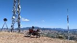
Snowy Mountain visitors centre.

For many people this is the first sight of Jindabyne as they get off the bus on a ski holiday - most people would only have seen it covered in snow. It's a sort of all-purpose centre - information, coffee shop, cinemas, bus station, national parks office, museum and pickup point for new arrivals.
Jindabyne is an interesting enough to walk around for a while - I gave myself until about 10am before packing up the rest of my gear and heading out. The population of Jindabyne, according to the census is around 2000 people, but there are facilities, hotels and restuarants for far more than that due to the busy ski season. The town has had a varied history - the alpine cattle properties, gold rush, the construction of the Snowy Scheme and more recently winter recreation.
At the edge of the national park is a checkpoint looking for spies. Comprehensive identity papers are required for the background checks.

Or you could just pay for a parks pass") There is a fee for entering the park, but if you are just passing through without stopping or using the park facilities you can get a free pass.
There is a fee for entering the park, but if you are just passing through without stopping or using the park facilities you can get a free pass.
Looking up at the hills above Thredbo - you can see the top of one of the chair lifts.

Thredbo village is below the road level - I didn't go into the village as it's very touristy, there's only one road in and out and there's relatively little open there during the summer. That said - at least one of the chair lifts is operating all year round. The walking track to the top of Mount Kosciosko(Australias highest mountain) is quite popular and mountain bike tracks replace ski runs when the snow disappears.
Mount Kosciosko is on the other side of the ridge and can't be seen from here.
Wombat poo - distinctive cubic shape and deposited in a prominent place to mark territory.

This is a really nice road in summer - the yellow line markings are really distinctive. In this pic I am parked in one of the many large snow chain fitting bays alongside the road. This road doesn't see a lot of deep snow - there aren't any snow poles here. Notice the change in vegetation above the snow line.

Further up the road is Dead Horse Gap - this area does see deep snow(snow poles mark the road edges). There's a large turning area here as caravans and motorhomes arean't supposed to go any further(although I did pass a few coming back the other way??). After this the road becomes twisty!!!

There's some steep(both ways) winding roads now - lots of beautiful eucalypts and bush flowers in bloom add their scent to the fresh mountain air.....


Of course, the views add to the (pleasant) assault on the senses.
Roo near the turnoff to Tom Groggin:

Road past Tom Groggin:

Panorama from Scammells lookout - on the opposite side of the range from Thredbo now - so Mount Kosciosko is now not visible behind the mountains to the east.

Murray-1 hydro-electric power station

The Snowy Scheme had two major purposes - diversion of water for irrigation and generation of electricity. Water is delivered from the dams and lakes by a series of tunnels and pipes, eventually going on to the Murray river. In recent years, particularly during drought, there has been a lot of argument over how much water flow the Murray needs to remain "alive".
Closer in to show the turbines in the machine hall

It's a hot day and I stopped at Khancoban roadhouse for a bit of a break and lunch.

Basic sort of roadhouse and cafe, good service and great ham, cheese, tomato toastie!
Playground in Corryong - someone went to a lot of effort to build this.

By now it's starting to get towards the afternoon and I wanted to get to the film festival, so no more dilly dallying - just hop on the bike and chew up the distance.
Funny thing - you hear a fair bit about Victoria and speed/safety cameras as a fund raising tool, and I see my first one on this trip just as I enter Victoria, amazing.
As I head down Kiewa Valley Way I get hit by a sudden storm - I'm about to stop and take a break when it just as suddenly stops and the sun comes out again. As I scoot over Tawonga Gap and into Bright I see waterbombing helicopters and see smoke from the bushfires down the road - then by just turning my head I can see more stormclouds and lightning striking into the pine forests.
The bike got parked just beside the registration desk alongside a dozen bikes, half of which seemed to be TouraTech demonstrators.
Of course, the first people I know(from the AusTouring forum) are just finishing a brewery tour(whatever else) and we all troop off to watch "MotoSyberia 2.0 Reactivation" in the Info Centre next to the brewery.
MotoSyberia 2.0 Reactivation is about a group of Polish guys that are attempting to go further than they had managed on their earlier MotoSyberia trip to Magadan. They are completely insane. The movie is completely different to how you would expect a "normal" motorcycle travel film to be, scenery, mud, bears, mud, gigantic condoms, flooded rivers and heavy metal(proportions may vary - I think I missed some mud and flooded rivers).....
A few links and bits and pieces from the intertubes about the movie - the trailers give a bit of an idea of the mindset behind the film, the soundtrack works particularly well(in a beastly-666 way - see the movie to understand).
MotoSyberia 2.0 Reactivation:
Website: http://motosyberia.com/index_en.php
Ride report on ADVRider: http://www.advrider.com/forums/showthread.php?t=239330&page=58 (about 60 pages worth, but great photography)
Trailer 1: http://www.youtube.com/watch?v=nGABbXSUT8A
[youtube]http://www.youtube.com/watch?v=nGABbXSUT8A[/youtube]
Trailer 2: http://www.youtube.com/watch?v=9Zk8teCMNac
[youtube]http://www.youtube.com/watch?v=9Zk8teCMNac[/youtube]
Brian arrived and watched the last 15 minutes, and I think even that much exposure was enough for the normal human mind......
Checked into the caravan park, had some pizza and beers at the brewery and then off to the outdoor showing of "Mazungu" in the park.
In Mazungu, Phil Harwood does the first source to sea journey down the Congo river by kayak and raft. Amazing journey and Phils' dry to-camera monologues added to a long history of barking mad English adventurers - dangers included wildlife, bandits, constant irritating demands for money and the river itself. At one point Phil hires four men to accompany him for safety - they were constantly asked "Why haven't you killed and robbed him yet?"....
Muzungu:
http://www.canoeingthecongo.com
http://www.philharwood.co.uk/
Trailer: http://youtube.com/watch?v=DVjgRVjCp0A
[youtube]http://www.youtube.com/watch?v=DVjgRVjCp0A[/youtube]
And that's it for the day!
Got an early wake-up courtesy of the fishermen using the boat ramp, and couldn't get back to sleep properly before the sun started rising.
Lake - early
Due to the hills, town and trees to the east of my campsite, I couldn't get any photos of the sunrise, so I turned around and looked at the lake and the hills to the west as the sunlight hit them - the clouds still threatening to continue the rain added to the variety of light and colour.
Lake Jindabyne is an artificial lake created by the Snowy Mountain scheme - the old town of Jindabyne is somewhere at the bottom of the lake.
Island:
Campsite again - it's been raining occasionally overnight, so the bike cover and tent will need to dry out a bit(I hope).
Cloud rolling in:
I got most of my gear packed, but hung the tent and bike cover over a fence to dry out in the breeze for a little while. While that was happening I went for a walk over to the shopping centre for an egg and bacon roll.....
The bikes I saw last night head back into town and start queueing at the servo for fuel - they've come from Sydney to do the 300km lap around the alpine roads. If they get going they might manage two laps today!
Snowy Mountain visitors centre.
For many people this is the first sight of Jindabyne as they get off the bus on a ski holiday - most people would only have seen it covered in snow. It's a sort of all-purpose centre - information, coffee shop, cinemas, bus station, national parks office, museum and pickup point for new arrivals.
Jindabyne is an interesting enough to walk around for a while - I gave myself until about 10am before packing up the rest of my gear and heading out. The population of Jindabyne, according to the census is around 2000 people, but there are facilities, hotels and restuarants for far more than that due to the busy ski season. The town has had a varied history - the alpine cattle properties, gold rush, the construction of the Snowy Scheme and more recently winter recreation.
At the edge of the national park is a checkpoint looking for spies. Comprehensive identity papers are required for the background checks.
Or you could just pay for a parks pass
There is a fee for entering the park, but if you are just passing through without stopping or using the park facilities you can get a free pass.Looking up at the hills above Thredbo - you can see the top of one of the chair lifts.
Thredbo village is below the road level - I didn't go into the village as it's very touristy, there's only one road in and out and there's relatively little open there during the summer. That said - at least one of the chair lifts is operating all year round. The walking track to the top of Mount Kosciosko(Australias highest mountain) is quite popular and mountain bike tracks replace ski runs when the snow disappears.
Mount Kosciosko is on the other side of the ridge and can't be seen from here.
Wombat poo - distinctive cubic shape and deposited in a prominent place to mark territory.
This is a really nice road in summer - the yellow line markings are really distinctive. In this pic I am parked in one of the many large snow chain fitting bays alongside the road. This road doesn't see a lot of deep snow - there aren't any snow poles here. Notice the change in vegetation above the snow line.
Further up the road is Dead Horse Gap - this area does see deep snow(snow poles mark the road edges). There's a large turning area here as caravans and motorhomes arean't supposed to go any further(although I did pass a few coming back the other way??). After this the road becomes twisty!!!
There's some steep(both ways) winding roads now - lots of beautiful eucalypts and bush flowers in bloom add their scent to the fresh mountain air.....
Of course, the views add to the (pleasant) assault on the senses.
Roo near the turnoff to Tom Groggin:
Road past Tom Groggin:
Panorama from Scammells lookout - on the opposite side of the range from Thredbo now - so Mount Kosciosko is now not visible behind the mountains to the east.
Murray-1 hydro-electric power station
The Snowy Scheme had two major purposes - diversion of water for irrigation and generation of electricity. Water is delivered from the dams and lakes by a series of tunnels and pipes, eventually going on to the Murray river. In recent years, particularly during drought, there has been a lot of argument over how much water flow the Murray needs to remain "alive".
Closer in to show the turbines in the machine hall
It's a hot day and I stopped at Khancoban roadhouse for a bit of a break and lunch.
Basic sort of roadhouse and cafe, good service and great ham, cheese, tomato toastie!
Playground in Corryong - someone went to a lot of effort to build this.
By now it's starting to get towards the afternoon and I wanted to get to the film festival, so no more dilly dallying - just hop on the bike and chew up the distance.
Funny thing - you hear a fair bit about Victoria and speed/safety cameras as a fund raising tool, and I see my first one on this trip just as I enter Victoria, amazing.
As I head down Kiewa Valley Way I get hit by a sudden storm - I'm about to stop and take a break when it just as suddenly stops and the sun comes out again. As I scoot over Tawonga Gap and into Bright I see waterbombing helicopters and see smoke from the bushfires down the road - then by just turning my head I can see more stormclouds and lightning striking into the pine forests.
The bike got parked just beside the registration desk alongside a dozen bikes, half of which seemed to be TouraTech demonstrators.
Of course, the first people I know(from the AusTouring forum) are just finishing a brewery tour(whatever else) and we all troop off to watch "MotoSyberia 2.0 Reactivation" in the Info Centre next to the brewery.
MotoSyberia 2.0 Reactivation is about a group of Polish guys that are attempting to go further than they had managed on their earlier MotoSyberia trip to Magadan. They are completely insane. The movie is completely different to how you would expect a "normal" motorcycle travel film to be, scenery, mud, bears, mud, gigantic condoms, flooded rivers and heavy metal(proportions may vary - I think I missed some mud and flooded rivers).....
A few links and bits and pieces from the intertubes about the movie - the trailers give a bit of an idea of the mindset behind the film, the soundtrack works particularly well(in a beastly-666 way - see the movie to understand).
MotoSyberia 2.0 Reactivation:
Website: http://motosyberia.com/index_en.php
Ride report on ADVRider: http://www.advrider.com/forums/showthread.php?t=239330&page=58 (about 60 pages worth, but great photography)
Trailer 1: http://www.youtube.com/watch?v=nGABbXSUT8A
[youtube]http://www.youtube.com/watch?v=nGABbXSUT8A[/youtube]
Trailer 2: http://www.youtube.com/watch?v=9Zk8teCMNac
[youtube]http://www.youtube.com/watch?v=9Zk8teCMNac[/youtube]
Brian arrived and watched the last 15 minutes, and I think even that much exposure was enough for the normal human mind......
Checked into the caravan park, had some pizza and beers at the brewery and then off to the outdoor showing of "Mazungu" in the park.
In Mazungu, Phil Harwood does the first source to sea journey down the Congo river by kayak and raft. Amazing journey and Phils' dry to-camera monologues added to a long history of barking mad English adventurers - dangers included wildlife, bandits, constant irritating demands for money and the river itself. At one point Phil hires four men to accompany him for safety - they were constantly asked "Why haven't you killed and robbed him yet?"....
Muzungu:
http://www.canoeingthecongo.com
http://www.philharwood.co.uk/
Trailer: http://youtube.com/watch?v=DVjgRVjCp0A
[youtube]http://www.youtube.com/watch?v=DVjgRVjCp0A[/youtube]
And that's it for the day!


 bigrofl


